Dig with certainty
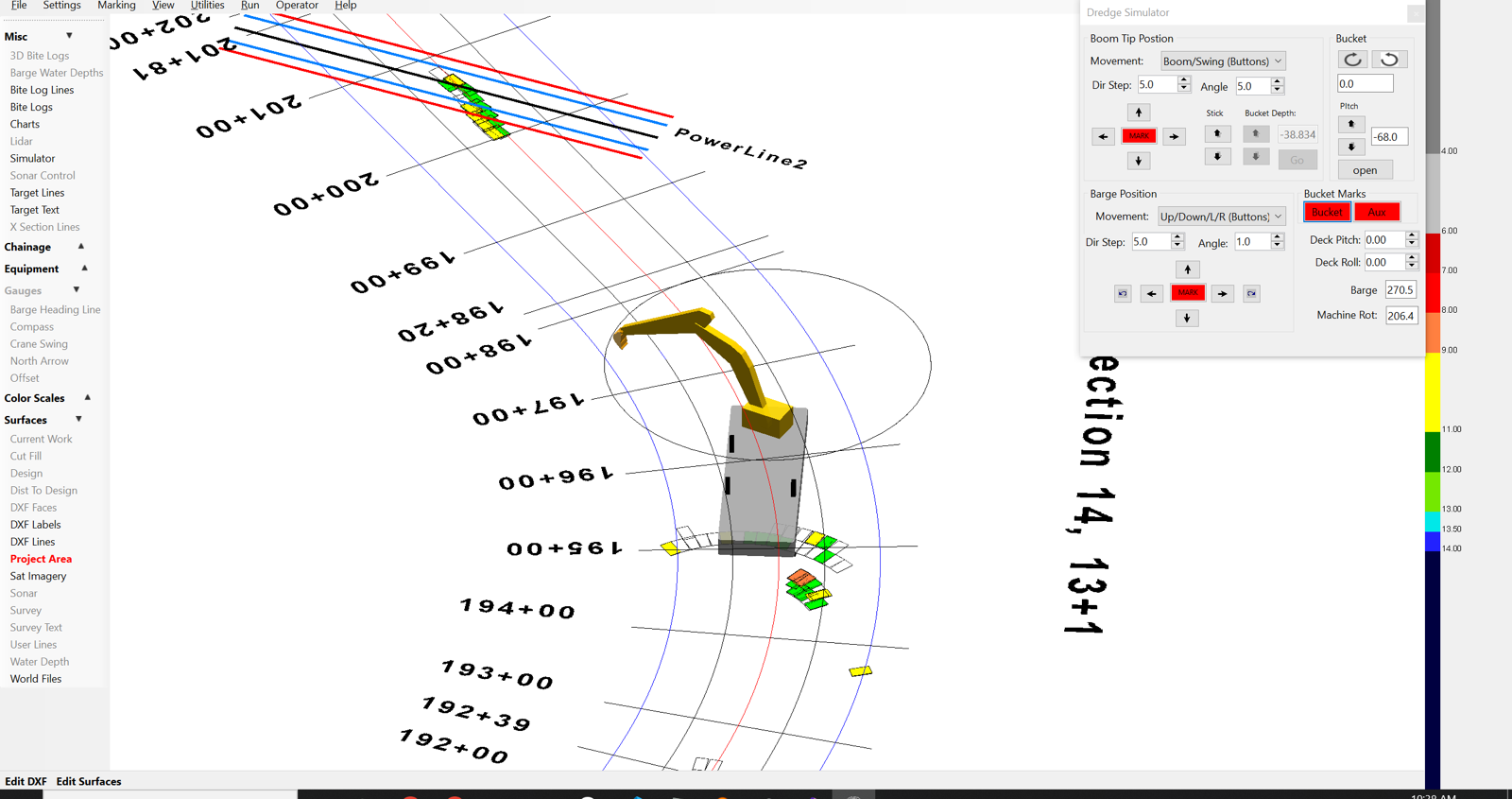
A live 3D model of your barge, boom, and bucket — driven by GPS, encoders, and inclinometers — shows the operator exactly where the bucket sits against design grade, corrected for tide, on every single bite.
Dredge Guidance · Production Tracking · Reporting
ClamVision turns your dredge’s sensors into a live 3D picture of the dig — bucket position, design surface, tide, and production — so your crew stops guessing and starts proving.
Why ClamVision
ClamVision was built from the ground up for clamshell and excavator dredging by the hydrographic surveyors at Sea Sight Survey — people who measure dredge projects for a living.
A live 3D model of your barge, boom, and bucket — driven by GPS, encoders, and inclinometers — shows the operator exactly where the bucket sits against design grade, corrected for tide, on every single bite.
Continuous surface differencing turns every recorded bite and sonar sounding into defensible volume numbers. Daily, shift, and project totals update themselves — no waiting on a post-dredge survey to know where you stand.
Relay Server and DredgeHQ cloud integration connect every dredge, survey boat, and office screen to one shared project. Push a new design surface from shore and every vessel has it in seconds.
The Command View
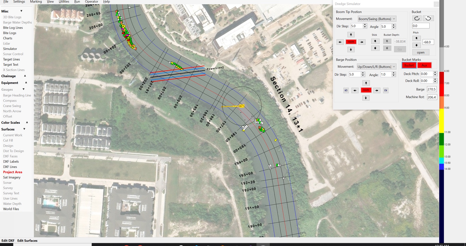
Georeferenced satellite imagery, chainage stations, design lines, the live barge and swing arc, and every recorded bite color-coded by depth — this is what your operator, superintendent, and client all see, updating together in real time.
How a Project Runs
Load soundings and surfaces from LandXML, DXF, XYZ, Shapefile, or native multibeam formats (KMall, S7K) to establish the existing bottom. No external CAD or GIS software required.
Import the required finished grade and tolerance. ClamVision renders it as a colored mesh in every view, in your project's coordinate system — UTM, local grid, or custom projection.
A structured workflow walks you through antenna offsets, boom geometry, and inclinometer alignment — then verifies the result against a known survey point. Test the whole setup in the office first with the built-in sensor simulator.
Every bite is recorded with position, depth, tide, and GPS quality. The work surface updates itself, volumes accumulate in real time, and under-dredged spots are flagged before the barge moves on.
Import the post-dredge survey, run cut/fill comparisons, and hand the client grade-compliance and production reports as PDF, CSV, or DXF — generated automatically, grounded in sensor data.
Capabilities
Fourteen integrated capabilities, one project file. No modules to stitch together, no data to shuttle between programs.
A live, sensor-driven 3D model of the barge, boom, bucket, and bottom — what the operator sees is what the machine is doing.
READ MORE →Built from the ground up for clamshell dredging — every bite logged automatically with position, depth, tide, and GPS quality.
READ MORE →Full articulated-arm modeling — boom, stick, and bucket angles fused with GPS and inclinometers for a live bucket-tip position.
READ MORE →Multi-channel GPS across the whole spread, built-in NTRIP RTK corrections, and a full offset model down to the bucket tip.
READ MORE →Chainage-based progress tracking along the pipeline alignment, with live cross-track offset and trench-grade profiles.
READ MORE →Import surveys from LandXML, DXF, XYZ, Shapefile, KMall, and S7K — and run the whole pre/post-dredge workflow without external CAD or GIS.
READ MORE →Live multibeam point clouds rendered right beside your equipment and design surface — see depth conformance in context.
READ MORE →Live tide gauges and NOAA water levels correct every depth to project datum — the operator never mentally adjusts for the tide again.
READ MORE →A structured calibration workflow with graphical verification — plus a sensor simulator to prove the setup before you mobilize.
READ MORE →Continuous surface differencing turns every bite into up-to-date, defensible volume numbers — no waiting for the post-dredge survey.
READ MORE →The documentation that contractors, clients, and regulators require — generated automatically as PDF, CSV, DXF, Shapefile, or KML.
READ MORE →Relay Server networking and DredgeHQ cloud monitoring connect every dredge, survey boat, and office screen to one shared project.
READ MORE →A native Android app running the same core engine as the desktop — live plan view, 3D visualization, and project management on a tablet.
READ MORE →Pre-built drivers for 90+ devices — GPS, INS, encoders, sonar, tide gauges — plus CAN bus, OPC UA, MQTT, and serial protocols.
READ MORE →Below the Waterline
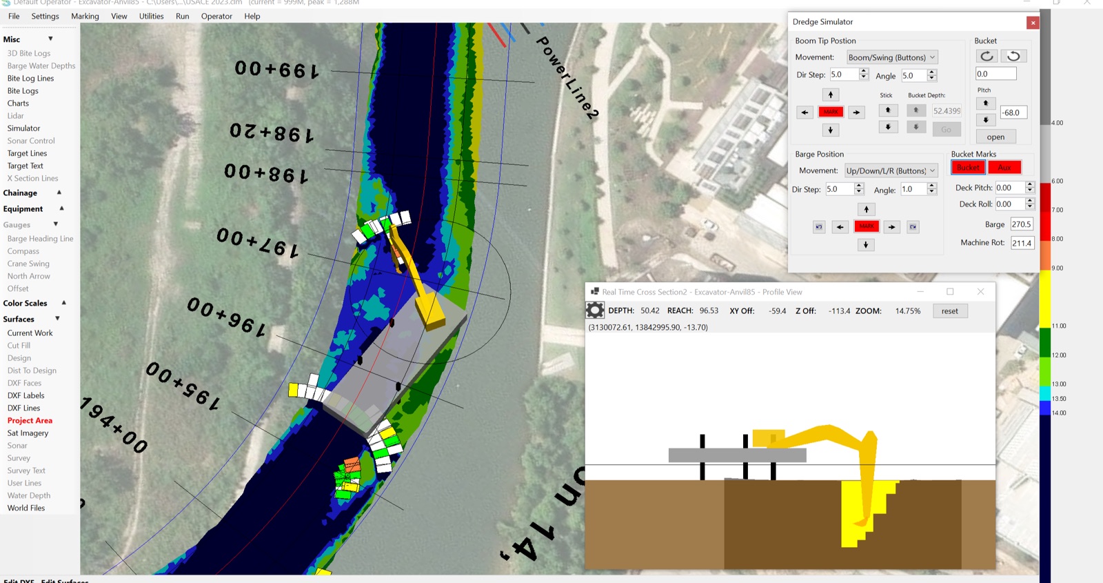
Multibeam and single-beam sonar, color-scaled depth surfaces, and live cross-sections put the invisible part of the job — the part you're paid for — right in front of the crew.
Plays Well With Your Hardware
If it's on your dredge, ClamVision can probably read it — and new drivers can be added for customer-specific hardware without touching the core application.
Who's Behind It
ClamVision is built by Sea Sight Survey — hydrographic surveyors with 50+ years of combined experience measuring marine construction from the Great Lakes to the Gulf. The people who write the code are the people who stand behind the survey data.
Every dredge spread is different. Tell us about your equipment and your project, and we'll spec a system, quote it, and get your crew trained.